Iruña-Veleia: Roman town (I BC-V AD)
Below article pays homage to the archaeologists at the Roman excavation site of Iruña-Veleia (10 km west of Vitoria-Gasteiz, Basque Country, Spain) during a visit in August 2017.
This article may serve as an English guide to the site, as it follows the route indicated below, to be found at the information office and on brochures. Additional images and descriptions are taken from Bibat Archaeology Museum Guide (Gil & Filloy, 2000) at Vitoria-Gasteiz, where most items found at the dig are housed on the third floor. Various items from Bibat Archaeological Museum, found at this site, are introduced here.
Translations of Spanish text (bottom) into English by G.Dijkman.
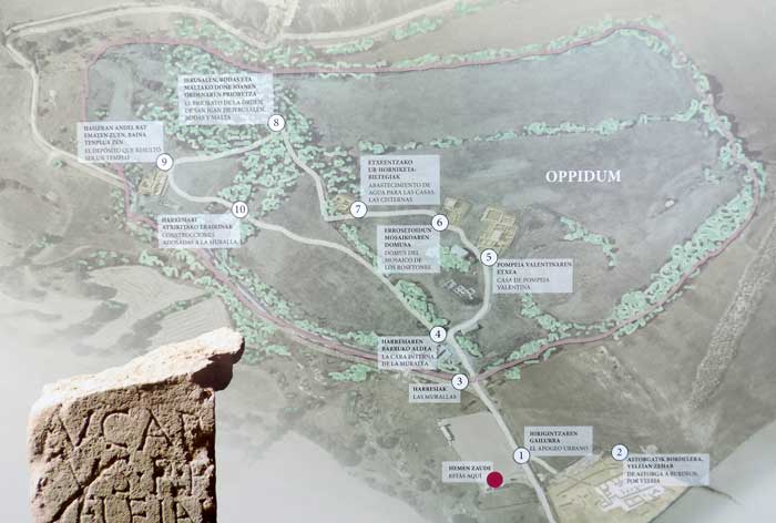
Image above: A tour of the excavation site (G.Dijkman, August 2017, picture from brochure and excavation office)
Points of reference: an itinerary for your visit
1) Urban highest point (El apogeo urbano)
2) Road from Astorga to Bordeaux, via Veleia, Iter XXXIV ‘Ab Asturica Burdigalam’ (De Astorga a Burdeos, por Veleia)
3) Walls (Las murallas)
4) Inside of the wall (La cara interna de la muralla)
5) Casa de Pompeia Valentina
6) Domus with mosaics of rose window motifs (Domus del mosaico de los rosetones)
7) Water supply for houses: cisterns (Abastecimiento de agua para las casas: cisternas)
8) Priory of San Juan of Jerusalem, Rhodes and Malta (El Priorato de la Orden de San Juan de Jerusalén, Rodas y Malta)
9) Deposit, which turned out to be a temple (El Depósito que resultó ser un templo)
10) Adjacent constructions to the wall (Construcciones adosadas a la muralla)
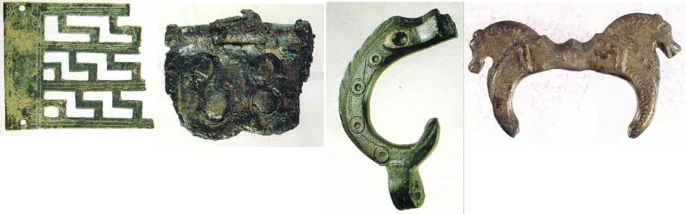
Images above, from left to right: Iruña-Veleia bronze findings: (Bibat Museum Guide item nrs.) 352 Decorative plate; IV-V AD.; smelted and forged bronze, with fretwork decoration; 59 cons. x 50 x 1 mm.; 353 Humeralia Hinges: 2nd half of I-II century AD.; forged brass-plated bronze; 28 x 23 x 4 mm.; 355 Zoomorphic buckle: 2nd half of IV, 1st half of V century AD; made of lost-wax cast bronze; 22 cons. x 30,5 x 7,5 mm.; 356 Zoomorphic buckle: 1st half V century AD.; gilded lost-wax cast bronze; 41 x 24 x 4 mm.
General introduction: location of the site
The site of Iruña-Veleia is situated in the municipal district of Iruña de Oca at about 10 km to the west of Vitoria-Gasteiz, occupying the spur of Arkiz, bordered to the north, south and east by a large meander of the river Zadorra. Of its expanse of 126 hectares, 11 belong to the walled enclosure.
History
The known occupation at the ancestral site of Iruña spans over more than 1500 years of history, from the first millennium BC to the 5th century AD. It seems that it was during this century when the late oppidum would be abandoned, not being documented as a new settlement until its use as a Priory of the Order of San Juan in the middle of the 14th century. After a little defined inhabitation during the end of the Bronze Age and throughout the Iron Age, it is during the first half of the 1st Century (Julio-Claudian period) when the first domus or Roman urban dwellings appeared.
Moving on into the 1st century, during the Flavian period, the city reached greater splendour, with luxurious dwellings and great public buildings, which must have formed an urban centre appropriate to the importance that the city of Iruña had acquired. In addition, during the 2nd century important beautification works and improvements to the urban facilities were carried out. The settlement was referred to as Veleia in the ancient sources by Pliny and Ptolemy.
During the 3rd century, the area of the settlement reduced in size, although without a doubt it is in this period which we know the least about. At the end of this century or at the beginning of the next, the city walls were constructed which would be the last great works to be carried out in the city.
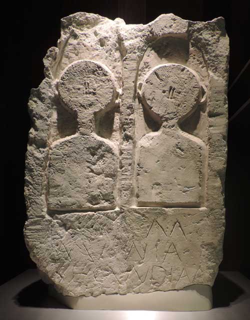
Image above (Bibat Archaeological Museum item 472): Funerary stele Iruña-Veleia (Trespuentes-Víllodas); Late Roman Empire (284-476 AD); Sculpted in white limestone; 590 cons. x 405 x 215 mm.
Rectangular tombstone, on top there are two levelled busts in bas-relief, with schematically incised features, defining the nose, eyes and ears, each situated underneath banked arches. In the lower part of the stele, there is the inscription of 140 x 305 mm, with three legible lines, and an illegible fourth. The letters are 35 mm high, of irregular level.
It reads: D(IIS) M(ANIBUS / AVNNIA / SECVNDIANA; To the Manes gods. Aunia Secundiana
The walled city
The city of Veleia was walled at un unknown date in the late 3rd or early 4th century A.D., creating the divided areas of the site that remain of this today. This walled area, usually called oppidum, was the place in which most of the archaeological interventions were carried out from the end of the 19th century until the new approach of the interventions that began in 2010.
The fortification is therefore the area of the site most subjected to historical analysis and is also its best known. However, gaining even the smallest insight into the complex reality of society at the time is still a difficult task, and this is information, which will continue to be uncovered as new investigations are conducted.
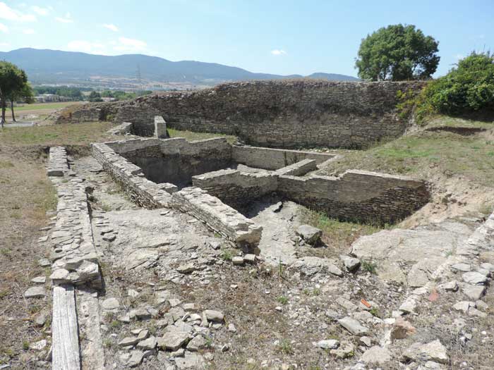
Image above: inner walls of the site (G.Dijkman, August 2017)
Álava’s Archaeological Heritage - The Roman town of Iruña-Veleia
Iruña-Veleia is one of the finest Roman settlements in the Basque Country. The town (called Iruña in Basque) developed from a pre-Roman settlement that stood on a bend in the River Arkiz. Its strategic location and its links with Iter XXXIV road between Astorga and Bordeaux (Ab Astorica Burdigalam) allowed it to grow and flourish in the early centuries A.D.. Archaeological digs have brought to light major buildings which evidence that this was an important town in its day, including market, a temple, residential areas containing dwellings of various types, cisterns, etc.
In the third and fourth centuries A.D. the town of Veleia underwent a period of change in which its borders retreated: from an area of about 126 ha it shrank to an 11 ha walled town (oppidum). The construction of the town walls were the last great public work carried out in the town. After this, it fell into decline and was subsequently abandoned and forgotten by the late Middle Ages.
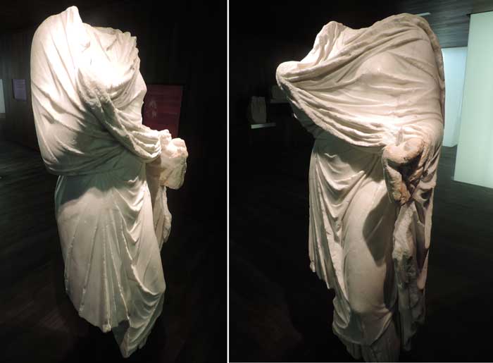
Image above: (Bibat Archaeological Museum item 474): Female sculpture Iruña-Veleia (Trespuentes-Víllodas); Early Roman Empire, 2nd half of the first century - 1st half of the second century AD, sculpted in white marble; 1480 cons. x 680 x 450 mm. Female sculpture, without head, right hand and feet. She is dressed in a tunic and shroud, falling down in elegant folds covering her entire body. Judging by its principle attributions, the most likely interpretation is an allegory of Fortuna or a representation of Livia or Agrippina. This exceptional and elegant sculpture is sculpted from Carrara marble, probably imported directly from Italy, or perhaps via one of the main peninsular capitals.
The urban space and the road
Veleia is known principally as an important large inhabited town of the Roman era, hence the Basque name of ‘Iruña’, meaning ‘city’ in Basque Country. The other two major historic settlements are Pamplona, which carries the Basque name Iruña (Pamplona-Iruña) and Oiasso, nowadays called Irún. These inhabited areas, however, cover many more centuries. Their roots date some 3000 years back, when the higher reaches of the river Arkiz were occupied, in a protected and steep meandering of the river nowadays called Zadorra.
During the Iron Age, a large settlement arose here, which developed into a Roman city, taking advantage of its strategic position and its connection with the road that connected Astorga and Burgos with Bordeaux (Ab Asturica Burdigalam), named Iter XXXIV.
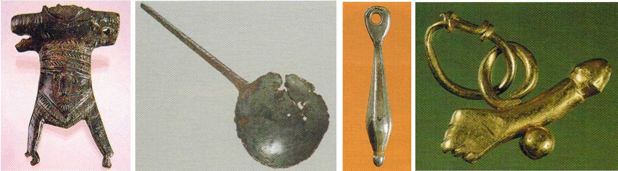
Image above (from left to right): metal objects encountered at Iruña-Veleia; Bibat Museum Item numbers 112: Aplique decorated on a container (Situla); IV-V centuries AD; smelted bronze; 64 cons. x 53 x 12 mm; 242. Spoon (Ligula), southeast wall; Roman era, smelted and forged bronze with silver-coated cap; 58 cons. x 23,5 x 5,8 mm.; Instrument used for chirurgical purposes; 382 Pendant (Inaures: earring); 2nd half of I-II century AD; forged silver; 33 x 5,5 mm.; 385 Pendant-amulet (Amuletum); under research; Roman era; smelted, forged and welded gold; 19,9 x 8,3 x 5,5 mm.; Phallic ornament of personal use consisting of various pieces welded together, used as a prophylactic amulet against the evil eye, representing fecundity and abundance.
After it had known considerable growth and reached its zenith in the first centuries AD, the city underwent important changes between the III and IV centuries AD, in a time not well-known, followed by its apparent downfall. The most striking element of these changes was the construction of the wall, which, despite its impressive dimensions, considerably reduced the urban outer limits, although large areas outside of the oppidum were still inhabited. This indicated a great preoccupation for safety in this convulsive area at the time.
Henceforward, Veleia fell into oblivion. It was a period where only a few medieval villages were known to exist, and the Priory of Saint John of Jerusalem, Rhodes and Malta, which raised an incomienda by building a church and various constructions in the XIV century. After this place had been deserted, the city ruins of Iruña and its surrounding area served as cultivation land and convenient quarries for the supply of stones, which were used to construct churches and houses.
Finally - a curiosity -, it was precisely here at Iruña that the famous Battle of Vitoria took place in 1813, with the troops of the Duke of Wellington passing the Trespuentes Bridge, on their way to attack the French army of Joseph Bonaparte.
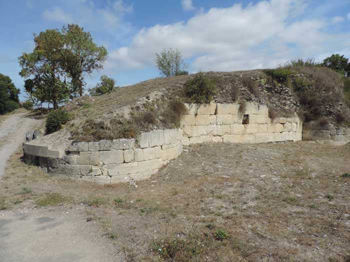
Image above: outer walls of the site (G.Dijkman, August 2017)
A tour around the site
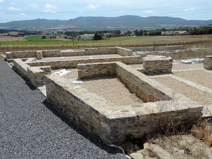
Image above: macellum (roofed market place) on the 'Ab Asturica Burdigalam' road connecting Astorga to Bordeaux via Veleia (G.Dijkman, August 2017)
2) From Astorga to Bordeaux, via Veleia
Veleia occupied a position of great strategic importance in the outer eastern Plain. The Roman road ‘Ab Asturica Burdigalam’ ran through this area, and connected Astorga (ES) with Bordeaux (FR), known as Iter XXXIV. This important highway was a public road for regional communication, owned by the Roman Empire. Hence, it provided supply stations to facilitate communication and trade goods.
Where we stand now, the road entered the city and became an urban road, with pavements and porches through which access was possible to contiguous buildings.
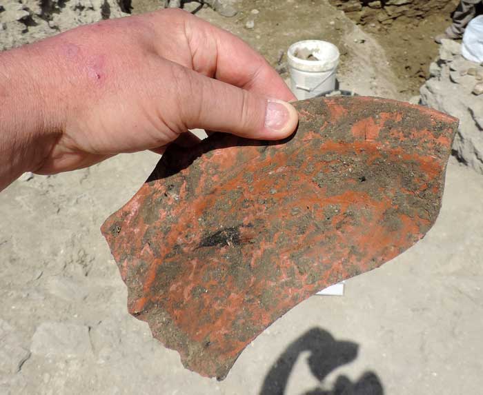
Image above: excavated on the spot by archaeologists, a piece of Roman Terra Sigillata, near the macellum (G.Dijkman, August 2017)
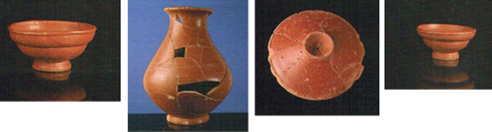
Image above, from left to right, Hispanic Terra Sigillata findings from Iruña-Veleia: 2nd half I-II centuries AD. Lathed ceramics, sintered engobe, oxidised baking; Bibat Museum nrs. 44. Jar (86 ∅ x 178 mm.); 47. Perforated lid (160 ∅ x 51 mm.); 50. Bowl (80 ∅ x 40 mm.); 51. Bowl (120 ∅ x 57 mm.), all pieces originally from the ‘alfares’ (potteries) in the region of Tritium Magallum (Tricio, La Rioja).
3) The wall
The wall was built at the end of the III or start of the IV century. Despite its more than 1200 metres, it merely protected a small part (11 Ha) of the city (oppidum), and most of the population continued to live outside of these limits, at least until the V century. The remaining wall reaches a maximum height of 9m, although in some parts all that remains is a low pile of stones. Its width varies between 4 and 5,5 metres.
The wall was constructed with two parallel layers of brickwork or stonemasonry, filling the space between them with small stone slabs cementing them together with simple mortar and limestone. The frontal southern part is one of the most monumental sections, with layers of round turrets at both sides of the entrance. On the exterior part of the wall, large stone blocks were used, some of which were taken from earlier buildings.
For the rest of the wall, material was used of inferior quality and the design was simplified, and rectangular instead of round turrets were constructed, but with equally- impressive dimensions.
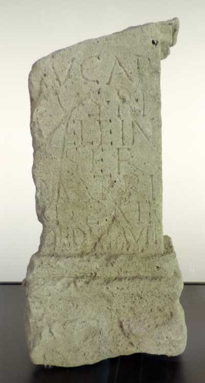
Image above: altar (G.Dijkman, picture taken at Bibat Museum, Vitoria-Gasteiz, August 2017)
Altar with votive inscription, found at the site, stating the name of 'Veleia', the first time this name has been recorded. This altar is now at Bibat Museum, Vitoria. It is made of stone and sandstone. The inscription reads:
[E]VCA[R] / [P]VS.R.P / VELEIAN / SER / MATRI / DEIA / DEDI[C]AVIT, translated as '‘Eucarpo, slave to the republic of the Veleians (or Veleian), offering this to the Mother Goddess’.
Restoration
Between 2011 and 2016, sections of the southern wall were restored. The aim of these works was to reduce the speed at which this part of the wall was deteriorating, and to ensure a proper understanding of it. Archaeological research has brought to light new findings, amongst which a striking votive altar. This altar is inscribed with the name of Veleia, and thus it confirms its identification with the ruins and, hence, the city of Iruña.
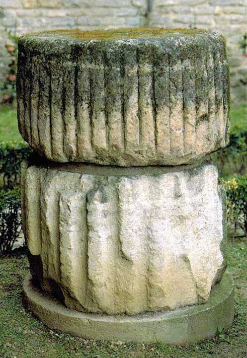
Image above: (Bibat Archaeological Museum item 480-481): Two column drums; Iruña-Veleia (Trespuentes-Víllodas); excavations by G. Nieto 1949-1950. Amidst the rubble of the south gate of the wall; Early Roman Empire (27 BC-235 AD); sculpted in sandstone; 480. Large: 970 Ø x 520 mm.; 481. Small: 900 Ø x 600 mm.
Architectural elements correspond to columns of considerable size. The large one presents a hollow to secure the successive drums through pegs and dowels. In the smallest drum, the carving is very deep, presenting flat marks separated by concave grooves. In the drum of bigger diameter, the carving is more superficial, with grooves in bevel and convex grooves.
These pieces were found ‘out of context’, and were part of the stuffing which filled the south gate, perhaps gathered for its reuse as construction material. Its origins could be traced back to the public area associated with the public building no. 1 (ex-castellum acquae).
4) The interior side of the wall
This sector was excavated by J.C. Elorza in 1975. These works were of short duration, as it was discontinued by the ‘National Congress of Archaeology’ held in Vitoria-Gasteiz around this date. The column drums found in the interior, confirm the reutilisation of earlier materials and the urgency of its construction. Nothing more for sure is known about the other constructions leaning against the wall immediately above the natural rock.
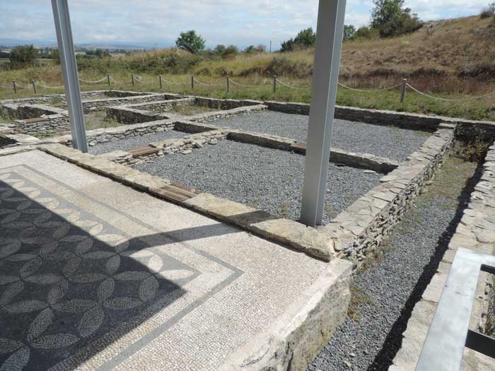
Image above: Casa de Pompeia Valentina (G.Dijkman, August 2017)
5) Casa de Pompeia Valentina
The name of Pompeia Valentina is inscribed in a fragment of ceramics recuperated during the excavations of this house. It concerns a house of Italic type (domus), typical of the powerful families of this era. The main façade featured a central entrance (faucēs) with two lateral rooms used for commercial purposes (tabernae).
The house was organised around a patio (atrium), around which the other dependences were situated: the main room (tablinium), where the pater familias used to receive his clients, the sleeping quarters (cubicula), the dining room (triclīnium) and the kitchen (culīna). The atrium, decorated with a mosaic pavement, featured an opening above (compluvium) to ventilate and illuminate the other rooms, which functioned as rainwater storage in an underground cistern (impluvium).
This domus was constructed in the first century AD and was altered afterwards, adding other rooms grouped around a large patio paved with flagstones, surrounded by columns.
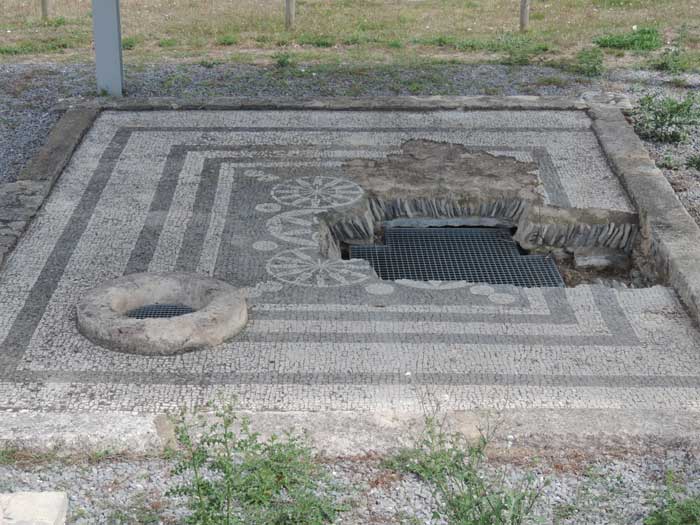
Image above: Domus with rose windows motif (G.Dijkman, August 2017)
6) Domus with mosaics of rose motifs
This house has a similar structure as the domus of Pompeia Valentina. Its original floor, however, is disguised with important reforms applied in the late Roman era. It takes its name from the motifs decorating the ground of the lower atrium, where the cistern is found. The partial breakage of the floor shows the details of its fabrication technique: small stones or tiles of various colours (teselae) embedded in a layer of lime mortar, as a way of fixing the design of the previously designed decoration.
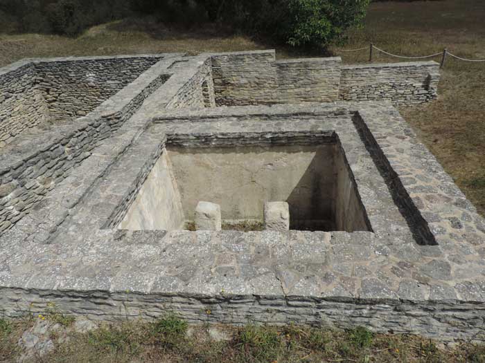
Image above: cisterns (G.Dijkman, August 2017)
7) Water supply for houses: cisterns
The excavations of Gratiniano Nieto in 1950, showed subterranean rooms constructed in the first century AD, which were entirely reshaped in the third century AD, after a fire. In addition, later excavations brought to light another cistern of this same last period. This cistern is of quadrangular design with two monolithic pillars supporting the cover. It shows walls of two panes of stonemasonry with a filling of mortar between the two panes and an interior designed to prevent the escape of water. It was no longer used in the fifth Century and it was filled with various materials, amongst which various human skulls.
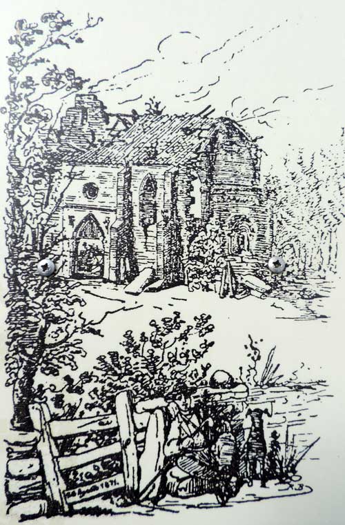
Image above: drawing by Ricardo Becerro de Bengoa (XIXth century) of the Priory of San Juan de Jerusalén, Rodas y Malta, picture taken of paper information leaflet (G.Dijkman, August 2017)
8) The Priory of San Juan of Jerusalem, Rhodes and Malta
In the Middle Ages, the members of this order constructed various buildings on these ruins, which were to become a priory - a type of branch of a major monastery. According to written sources, they “put back together the walls of the ancient area and also raised the Priory house”, which included various rooms and a church. Nowadays, its ruins are covered by vegetation and all that remains visible are some walls. Ricardo Becerro de Bengoa, in the XIX century, visited these ruins and made this drawing.
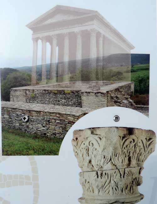
Image above: 'imaginary temple' & temple basic structure, with a Corinthian capital, now at the Archaeological Museum Vitoria-Gasteiz (information brochure at the dig)
The capital is now at the Bibat Museum, which offers the following description:
Iruña-Veleia, Víllodas-Trespuentes; Stone and sandstone, late Roman era; it has three broken faces, whilst the fourth is leaning to the wall of the building. It features all three classic elements of Corinthian architecture: a listel, astragal, acanthus or calyculus leaves, or wisps. An abacus in the form of a curvilinear square with concave sides forms the crown of the capital.
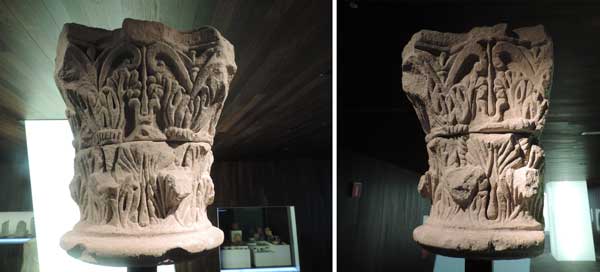
Image above: (Bibat Archaeological Museum item 475, 2000): Corinthian capital, Iruña-Veleia (Trespuentes-Víllodas); Early Roman Empire (27 BC-235 AD); sculpted in sandstone; 650 x 630 x 620 mm.
Large Corinthian capital, showing three of four faces, i.e. its fourth face would lean against the wall of the building in question. It is fragmented in two halves. Despite its somewhat summary execution, it presents all the canonical elements of the order to which it belonged: a listel, astragal, two rows of spiralled acanthus or calyculus leaves (wisps), whilst an abacus in the form of a curvilinear square with concave sides forms the crown of the capital. The origins of this architectural element could be linked to public use associated to a public building no.1 (ex-castellum acquae).
9) Temple
The location of these mighty ruins at the beginning of the XIXth century made its discoverer priest Jaime Verastegui assume that it was a large deposit of water distribution. The subsequent discovery of a series of shafts and a large Corinthian capital, however, unmistakably indicates a large building of public character with architectural features that are characteristic of official buildings. Most probably, we stand before the foundations of a temple, which by its mere location has to be one of the most important sacred buildings of the city.
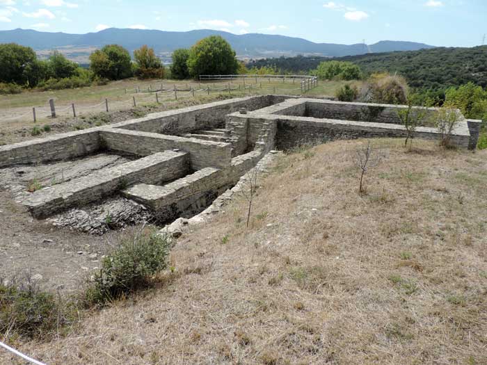
Image above: temple with a view to the southwest (G.Dijkman, August 2017)
10) Constructions adjacent to the wall
The excavations by Gratiniano Nieto in this area in the 1950s revealed an alley and various other late Roman constructions attached or adjacent to the wall, which defy interpretation. It is interesting to get closer to the interior decoration of the wall of the oppidum and observe the various restorations.
Source
- texts: paper information brochure (edition: www.araba.eus); displays around the sight; exhibits and descriptions at Bibat Museum, Vitoria-Gateiz; G.Dijkman
- photographs: G.Dijkman, during a visit to the site in August 2017
- photographs & texts: Gil Zubillaga, Eliseo & Filloy Nieva, Idola (2000) - Bibat Archaeological Museum Guide: La Romanización (en Álava, Catalogo de la exposición permanente sobre Álava en época romana del Museo de Arqueología de Álava), Guías del Museo, Diputación Foral de Álava, Departamento de Cultura, ISBN 84-7821-422-4
References
- https://turismo.euskadi.eus/es/patrimonio-cultural/conjunto-arqueologico-de-iruna-veleia/aa30-12375/es/
- Diputación Foral de Álava: www.alava.net; www.araba.eus
- http://www.alavaturismo.eus/index.php/en/heritage/museums/history/bibat-museum-of-archaeology
- https://tourism.euskadi.eus/en/museums/bibat-museum/aa30-12375/en/
Original Spanish text
Image (Bibat Archaeological Museum item 472): 472 Estela funeraria Iruña-Veleia (Trespuentes-Villodas); Época romana bajoimperial; Tallada en caliza blanca; 590 cons. x 405 x 215 mm. Lápida rectangular, que en su parte superior presenta dos bustos planos en bajorrelieve, con rasgos incisos muy esquemáticos que definen la nariz, los ojos y las orejas, situados bajo sendos arcos peraltados. En el tercio inferior de la estela aparece la inscripción, en un campo epigráfico de 140 x 305 mm., que conserva tres lÃneas legibles, y una cuarta no resonstruible. Las letras tienen 35 mm. de altura, presentan lÃneas de guÃa irregulares. Corresponde a: CAA 9067. Su lectura es: D(IIS) M(ANIBUS / AVNNIA / SECVNDIANA A los dioses Manes. Aunia Secundiana Elorza (1967, p.40) Elorza (1970, p.247)
Yacimiento Romano de Iruña-Veleia, Patrimonio Arqueológico de Álava - La ciudad Romana de Iruña-Veleia
Iruña-Veleia es uno de los grandes yacimientos de época romana del territorio vasco. La ciudad (Iruña en euskera) se desarrolló a partir de un núcleo de p0blación prerromano instalado en el meandro de Arkiz. Su estratégica posición y su conexión con la calzada Iter XXXIV que comunicaba Astorga y Burdeos (Ab Astorica Burdigalam), favorecieron su crecimiento y auge durante los primeros siglos de nuestra era. Las excavaciones arqueológicas han sacado a la luz importantes edificios que nos muestran la relevancia que tuvo en su día esta ciudad: mercado, templo, espacios de habitación con viviendas de diversos tipos, cisternas, etc. Entre los siglos III y IV d.C. se inicia un período de transformaciones. Veleia reduce su perímetro pasando de ocupar unas 126 hectáreas a centrar la actividad en las 11 del recinto amurallado (oppidum). La construcción de estas murallas sería la última gran obra pública realizada en la ciudad. A partir de entonces fue entrando en un período de decadencia, abandono y olvido hasta su definitivo despoblamiento ya muy avanzada la Edad Media.
Image 474 Escultura femenina Iruña-Veleia (Trespuentes-Víllodas); Época romana altoimperial, segunda mitad siglo I d.C. - primera mitad II d.C.; tallada en mármol blanco; 1480 cons. x 680 x 450 mm. Escultura femenina a la que le falta la cabeza, la mano derecha y los pies. Va vestida con túnica y manto que cae en amplios y elegantes pliegues cubriendo todo el cuerpo. Entre las principales atribuciones que se han barajado, están la de una alegoría de la Fortuna o una representación de Livia o Agripina. Esta excepcional pieza de estatuaria, está tallada en mármol de Carrara, correspondiendo seguramente a un elemento importado bien directamente desde Italia, bien a través de alguna de las principales capitales peninsulares. Blázquez (1956, p.236), Nieto (1958, pp. 201-203; lám. XXV), Gil (1997d, pp. 128-129)
El espacio urbano y la calzada
La excavación de esta gran superficie responde a los criterios científicos establecidos por el nuevo proyecto de investigación iniciado en 2010 a raíz del Plan Director de Iruña-Veleia, impulsado por la Diputación Foral de Álava en colaboración con la Universidad del País Vasco.
Veleia es conocida fundamentalmente por su importancia como gran núcleo de población en época romana, de ahí su denominación como Iruña, la ciudad en Vasco, del mismo modo que las otras dos grandes poblaciones históricas de Vasconia, Pamplona-Iruña y Oiasso-Irún, las ciudades por antonomasia del territorio en la Antigüedad.
Sin embargo, su existencia como núcleo habitado se extiende durante muchos siglos más. Su origen se remonta al menos unos tres mil años atrás, cuando se ocupó la parte alta del espolón de Arkiz, en un protegido y escarpado meandro del rio que hoy llamamos Zadorra. Allí se desarrolló una importante población durante la Edad de Hierro a partir de la cual crecería después la ciudad romana, aprovechando su estratégica posición y su conexión con la via que comunicaba Astorga y Burgos (Iter XXXIV).
Tras conocer un gran crecimiento y auge en los primeros siglos de nuestra era, la ciudad sufrió importantes modificaciones entre los siglos III y IV, iniciándose un período poco conocido de aparente decadencia. El elemento más evidente de aquellos cambios fue la construcción de la muralla que, pese a sus imponentes dimensiones, redujo considerablemente el perímetro urbano (aunque amplias zonas seguirían habitadas fuera del oppidum) evidenciando una gran preocupación por la seguridad, propia de aquellos tiempos convulsos.
A partir de entonces, Veleia fue entrando en un profundo olvido, sólo interrumpido por breves referencias a la existencia de algunas aldeas altomedievales y al Priorato de la Orden de San Juan de Jerusalén, Rodas y Malta que levantó una encomienda con iglesia y diversas construcciones a partir del siglo XIV. Tras su abandono, las ruinas de la ciudad, de Iruña para los habitantes del entorno, sirvieron de tierras de cultivo y fácil cantera para abastecimiento de piedras con las que construir sus iglesias y sus casas.
Para finalizar y como dato curioso, citar que fue precisamente aquí, en Iruña, uno de los puntos en los que se inició la famosa batalla de Vitoria de 1813, al atravesar las tropas del Duque de Wellington el puente de Trespuentes, en su ataque el ejército francés de José Bonaparte.
2) De Astorga a Burdeos, por Veleia
Veleia ocupaba una posición de gran valor estratégico en el externo occidental de la Llanada. Por aquí discurría la calzada romana que unía Astorga con Burdeos, conocida como Iter XXXIV. Esta importante vía de comunicación tenía carácter publico, propiedad des estado romano, y por ello estaba provista de estaciones de servicios o postas para facilitar las comunicaciones y el tráfico de mercancías. Por el lugar donde non encontramos el camino penetraba en la ciudad y se transformaba en una vía urbana, con aceras porticadas que permitían el acceso a los edificios colindantes.
3) La muralla
La muralla fue construida a finales del siglo III o inicios del IV. A pesar de sus más de 1.200 metros de trazado, sólo protegía una pequeña parte de la ciudad, el llamado oppidum (11 Ha), por lo que buena parte de la población siguió viviendo fuera de sus límites, al menos hasta el siglo V. Los restos conservados alcanzan 9 m de altura máxima, aunque en algunos lugares apenas queda una hilada de piedras. Su anchura varía entre los 4 y los 5’5 metros. La muralla se construyó a partir de dos lienzos paralelos de sillería o mampostería, rellenándose el espacio entre estos con pequeñas lajas de piedra unidas con una argamasa pobre de cal y arena. El frente sur es uno de los tramos más monumentales, con impuestos torreones circulares flanqueando la puerta de entrada. En el paño exterior se emplearon grandes bloques de piedra, algunos reaprovechados de edificios anteriores. En el resto del trazado se utilizó material de peor calidad y se simplificó el diseño, construyéndose torreones rectangulares en lugar de circulares, pero manteniendo sus potentes dimensiones.
Image: Ara con inscripción votiva - Altar; Iruña-Veleia, Villodas-Trespuentes; Piedra, Caliza; Época romana; transcripción: [E]VCA[R] / [P]VS.R.P / VELEIAN / SER / MATRI / DEIA / DEDI[C]AVIT; traducción: ‘Eucarpo, esclavo de la república de los veleianos (o veleiana), lo dedicó a la Diosa Madre’.
Restauración
Entre los años 2011 y 2016 se restauraron algunos tramos de la zona sur de la muralla. Estas intervenciones tuvieron como objetivo frenar el proceso de deterioro y asegurar la correcta lectura de las murallas. Incluyeron actuaciones arqueológicas que dieron lugar a nuevos hallazgos, destacando un ara votiva con una inscripción en la que aparece el nombre de Veleia y que, por tanto, confirma definitivamente la identificación de las ruinas de Iruña con dicha ciudad.
Image: 480-481 Dos tambores de columna Iruña-Veleia (Trespuentes-Víllodas). excavaciones G. Nieto 1949-1950. Entre los escombros de la puerta sur de la muralla; Época romana altoimperial; Tallada en arenisca; 480. Mayor: 970 Ø x 520 mm.; 481. Menor: 900 Ø x 600 mm. Elementos arquitectónicos correspondientes a columnas de grandes dimensiones. Uno de ellos - el mayor - presenta del hueco para sujetar los sucesivos tambores mediante tacos y espigas. En el tambor más pequeño, la talla es muy profunda, presentando las estrías planas separadas por acanaladuras cóncavas. En el de mayor diámetro, la talla es más sumaria, con acanaladuras en bisel y estrías convexas. Estas piezas se hallaron descontextualizadas, formando parte del relleno que colmataba la puerta sur, tal vez acopiadas para su reutilización como material constructivo. Su procedencia originaria podría situarse en el área pública asociada al edificio público no.1 (ex-castellum acquae). Nieto (1958, pp. 109 y 152; lám. LXXII)
4) La cara interna de la muralla
Este sector fue excavado por J.C. Elorza en 1975. La actuación realizada respondió a una iniciativa sin continuidad relacionada con el Congreso Nacional de Arqueología celebrado en Vitoria-Gasteiz por estas fechas. Los tambores de columna que se aprecian en el paño interno, confirman la reutilización de materiales previos y la premura de su construcción. No se conoce con seguridad la funcionalidad de las otras edificaciones que se adosan a la muralla construidas directamente sobre la roca natural.
5) Casa de Pompeia Valentina
El nombre de Pompeia Valentina aparece inscrito en un fragmento de cerámica recuperado en la excavación de esta casa. Es una vivienda de modelo itálico (domus) típica de las familias pudientes de la época. La fachada principal presentaba una entrada central (fauces) con dos estancias laterales de uso comercial (tabernae). La casa se organizaba a partir de un patio (atrium) en torno al cual se situaban las demás dependencias: la principal (tablinum), donde el pater familias recibía a su clientela, los dormitorios (cubicula), el comedor (triclinium) y la cocina (culina). El atrio, decorado con un pavimento de mosaico, presentaba una abertura superior (compluvium) para ventilar e iluminar las otras estancias, así como para permitir el almacenamiento del agua de lluvia en una cisterna subterránea (impluvium). Esta domus fue construida en el siglo I y modificada después, con el añadido de nuevas dependencias organizadas en torno a un gran patio enlosado rodeado de columnas.
6) Domus del Mosaico de los Rosetones
Esta casa posee una estructura similar a la domus de Pompeia Valentina, pero su planta original está enmascarada por importantes reformas realizadas en época tardorromana. Toma su nombre de los motivos del mosaico que decora el suelo del atrio bajo el cual se encuentra la cisterna. La rotura parcial del pavimento permite apreciar los detalles de su técnica de fabricación: pequeñas piedras de diversos colores (teselae) incrustadas en una capa de mortero de cal componiendo la decoración previamente diseñada.
7) Abastecimiento de agua para las casas: las cisternas
Las excavaciones de Gratiniano Nieto, en 1950, documentaron en este punto tres estancias subterráneas construidas en el siglo I d.C. y fuertemente remodeladas en el siglo III, tras un incendio. Actuaciones posteriores detectaron, además, una cisterna de esa última época. Este aljibe es de la planta cuadrangular con dos pilares monolíticos para soportar la cubierta. Presenta muros de dos hojas de mampostería con relleno de argamasa entre ambas e interior enlucido para evitar fugas de agua. Dejó de utilizarse en el siglo V e se colmató con diversos materiales de relleno, entre los que aparecieron diversos cráneos humanos.
8) El Priorato de la Orden de San Juan de Jerusalén, Rodas y Malta
En la Edad Media, los miembros de esta orden construyeron sobre las ruinas romanas diversos edificios para asentar un priorato (especia de sucursal de un monasterio mayor). Según las fuentes escritas “recomppusieron las murallas del antiguo recinto y alzaron también su casa prioral” que incluiría diversas dependencias y una iglesia. En la actualidad, sus ruinas están ocultas por la vegetación y apenas se distinguen algunos muros. Ricardo Becerro de Bengoa, en el siglo XIX, visitó las ruinas y realizo este dibujo.
Iruña-Veleia, Víllodas-Trespuentes; Piedra, Arenisca; Época romana altoimperial; tiene falladas tres caras, adosándose por la cuarta a la pared del edificio. Se reconocen en él los elementos clásicos del orden arquitectónico corintio al que pertenece: listel, astrágalo, hojas de acanto y calículos o volutas. Un ábaco en forma de cuadrado curvilíneo de lados cóncavos corona el capitel.
Image 475 Capitel corintio Iruña-Veleia (Trespuentes-Villodas); Época romana altoimperial, mediados siglo I d.C. - II d.C.; Tallado en arenisca; 650 x 630 x 620 mm. Capitel corintio de grandes proporciones. Presenta talladas tres de sus caras, reservándose sin devastar la cuarta, por la que se adosaría a la pared del correspondiente edificio. Está fragmentado en dos mitades. Aunque de ejecución algo sumaria, presenta todos los elementos canónicos del orden al que pertenece: listel, astrágalo, dos filas de hojas de acanto, volutas y caulículos, coronándolo un ábaco en forma de cuadrado curvilíneo de lados cóncavos. La procedencia originaria de este elemento arquitectónico, podría situarse en el área pública asociada al edificio público no. 1 (ex-castellum acquae). Nieto (1985, p.151; lám. LXXII); Gil (1997d, pp.132-133)
9) El Depósito que resultó ser un templo
La localización a comienzos del siglo XIX de estas potentes ruinas, hizo suponer a su excavador, al sacerdote Jaime Verastegui, que correspondían a un gran depósito de distribución de aguas. Sin embargo, la recuperación en sus trabajos de una serie de fustes y de un capitel corintio de grandes dimensiones, indica la existencia inequívoca de un gran edificio de carácter público, con la decoración arquitectónica propia de los edificios oficiales. Muy probablemente non encontramos ante la cimentación de un templo que por su localización debió de ser uno de les edificios sagrados más importantes de la ciudad.
10) Construcciones adosadas a la muralla
Los trabajos de excavación de Gratiniano Nieto en esta zona, realizados en la década de 1950, posibilitaron el descubrimiento de un callejón y diversas construcciones tardorromanas e difícil interpretación, adosadas a la muralla. Es interesante acercarse al paramento interior de la muralla del oppidum para observar sus diversas reparaciones.

